Abstract: Thousands of lives are sacrificed to the EU’s border regime in the Mediterranean every year. As a means of justification serves the reference to the medieval Mediterraneum constructed as the border between a ‘Christian Occident’ and an ‘Islamic Orient’. Historical research knows that this image is wrong, but cannot implement its knowledge in public discourse..
DOI: dx.doi.org/10.1515/phw-2020-14965
Languages: English, German
Every year, the EU’s border regime in the Mediterranean costs thousands of lives. This massive death toll is justified by referring to the medieval Mediterraneum, construed as a border between a “Christian Occident” and an “Islamic Orient.” Historical research knows that this conception is wrong, but has thus far been unable to implement its knowledge in public discourse.
Shades of Borders
Geographically, the Mediterranean is an inland sea that connects the coasts of the Middle East, North Africa and Southern Europe. Europe is separated from Asia and Africa only by the narrow straits of the Bosporus and the Strait of Gibraltar, two continents being connected by the Sinai land bridge. The peninsulas of the Peloponnese and Italy as well as the various islands and archipelagos additionally facilitate crossing the Mediterranean. Current policy, however, is dominated by defining the Mediterranean as the southern border of Europe, where the European Border and Coast Guard Agency FRONTEX is deployed. Its activities not only aim to resolve practical issues (customs and border control), but also have strong ideological implications. At least those who postulate a European, Christian identity, supposedly endangered by migration from Asia and Africa, regard the inland sea as the border between different, seemingly irreconcilable cultural areas. In the legacy of biological racism, large population groups are once again being attributed adverse characteristics, cultural instead of racial ones, which make these groups as dangerous and despised as the alleged biological alterity of previous generations.
The construal of the Mediterranean as the southern border of Europe is a political symbol that rests on firmly established historical narratives. This can be demonstrated by the representation of Europe and the Mediterraneum in historical atlases. Maps of antiquity, when the Greeks sat “like ants or frogs around a swamp”[1] or the Roman Empire ruled the coasts, place the Mediterranean at their centre. The common representations of the Middle Ages shift this focus far to the north, to the territory of present-day Germany. Thus, the Mediterraneum becomes the periphery, the southern border of the continent of Europe, which is visualized as the actual site of history. This historical-geographical construction has in turn been used as a symbol to postulate a European-Christian identity in dissociation from a supposedly hostile Islam. See, for example, the sticker spread by the Identitarian Movement in 2017 that features Europe as a solitary peninsula projecting into the vast ocean. While the European silhouette exhibits the familiar cartographic image, the coast of North Africa has been airbrushed and Greece has been cut off, to suggest that Europe is geographically isolated.[2]
The Ocean as a Struggle Zone
These pictorial representations correspond to the canon of historical content characterizing history teaching at schools. Antiquity is mainly dominated by Greco-Roman history, but also by Jewish history, and thus is focused on the Mediterranean. For the Middle Ages, however, the focus lies on Christian Europe. The recent additions of the Crusades and the so-called “Reconquista” only partially compensate for this shift in historical focus, as they present the Mediterranean region primarily as a battle zone between Christians and Muslims. Thus, these themes also fit into the picture of a maritime area that is said to have been marked above all by confrontations between religiously and culturally different, mutually hostile groups. This further consolidates the image of the Mediterranean as the southern border of medieval Europe.
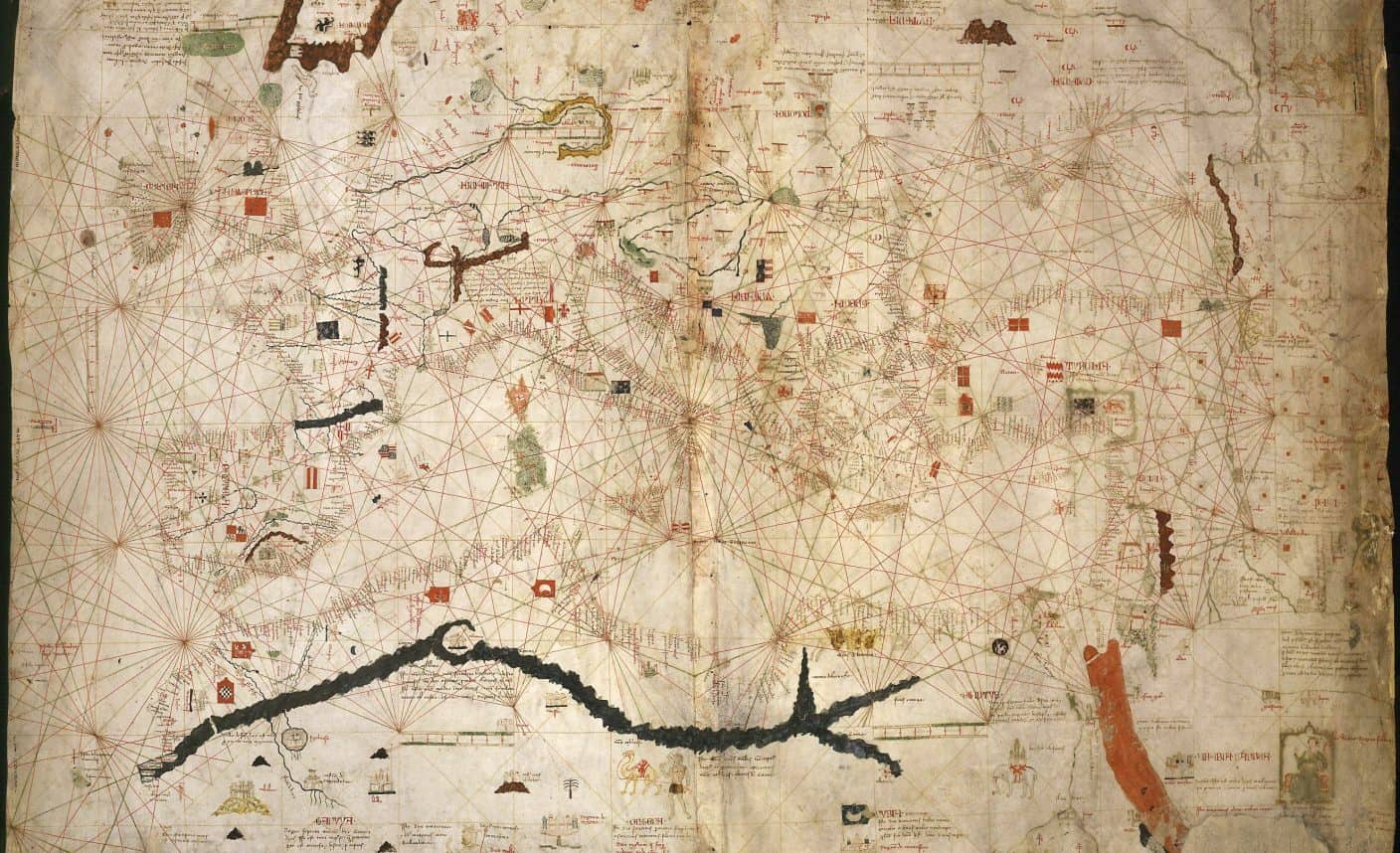
Historical scholarship has increasingly broken up this focus of the European Middle Ages in the last two decades. Inspired by the new interest in global history, research has focused on processes of contact and transfer between Asia, Africa and Europe, but also on the “entangled histories” of these regions, to show the manifold interactions across the Mediterranean. This can also be illustrated with cartographic material: since the 13th century, so-called portolan charts were produced in Italian port cities as well as in the Aragonese dominion, which traced the coasts of the Mediterranean and adjacent maritime areas out of interest in seafaring.[3] Their name comes from the fact that they were created from port lists. On the maps, which are hardly interested in inland conditions, the names of the ports are written at right angles to the coastlines and, together with other indications of rocks or shoals, served coastal navigation. In accordance with the trade routes regularly followed by Italian or Aragonese ships, these late medieval portolan maps show the coastlines of the Mediterranean and Black Seas and the west coasts of Africa and Europe from the Canary Islands to the south-western tip of the North Sea. The medieval depiction of these coasts appears strikingly modern because they are very similar to modern geographical representations. The northern waters — for example off Scotland, the Frisian North Sea coast or Scandinavia — are only sketched schematically on these portolan maps. Only a few place names were known from Norway or Denmark. For the maritime practitioners from the Mediterraneum, the coasts of the Caucasus or Northern Africa were much more familiar than the North Sea coast of present-day Germany.
Weaving Nets
It can be shown in many ways how closely people from Southern Europe, West Asia and North Africa were in contact and exchange with each other. This applies, for example, to seafarers and long-distance traders who transported goods from Central and South Asia to Europe. Ports such as Trabzon (Trapezunt) or Ayas (Lajazzo) served as transhipment points for goods travelling on the Silk Road from Central Asia to the West. In addition, the so-called “maritime Silk Road” connected the Indian Ocean via the Red Sea with Egypt. Here, Alexandria in the Nile delta served as a central transhipment point, where goods from the Indian subcontinent or from Southeast Asia were reloaded onto European ships, as well as products from the Nile valley or other regions of East Africa. The diversity and origin of Mediterranean merchandise are impressively documented, for example, in the Merchant’s Handbook by the Florentine Francesco Balducci Pegolotti.
Politically and culturally, Mediterranean actors were also in close contact with each other. Beyond the Crusades, alliances and enmities were generally based not on religious or cultural differences, but on concrete interests. Thus, Genoese and Venetians were usually hostile to each other and, given the opportunity, found coalition partners in the Byzantine or Ottoman Empire or even the Mamlukes. Economic and political cooperation could hardly be disrupted, not even by papal boycott demands, which were launched after the conquest of Acre in 1291 in order to prepare a renewed Christian conquest of Palestine. At the same time, Mediterranean realms tended to be extremely heterogeneous in terms of language and culture. Multireligiousness was the rule rather than the exception in Mediterranean medieval societies. Not even in the Crusader states was there any attempt at religious or cultural homogenization; rather, a wide range of religious beliefs existed in form of various varieties of Jewish, Christian and Islamic traditions. From a Central European perspective, the Roman-German emperor and Sicilian king Frederick II from the House of Staufer appears exotic — not least because of his cooperation with Muslim rulers and soldiers or because of his intellectual interests. Historiographical accounts of German emperors have long sought to portray and explain Frederick’s apparent exoticism. To Mediterranean actors, however, he represents the normal case of a ruler who cooperated with the elites of his empire regardless of religious denomination and who used the promotion of scholars for self-representation.
Bridges for Borders
Historical studies are well aware of the close connections among those populating the Mediterranean shores. However, this knowledge has not yet broadly entered European historical consciousness. The political claim to supposedly specifically Christian traditions and Western values, on the other hand, is based on older narratives that construed medieval Christianity in Europe in contrast to the oriental world of Islam. For current xenophobic political campaigns, but also for a maritime border regime claiming thousands of victims every year, older historical narratives prove to be disastrous associative spaces capable of bridging a conservative establishment and radical right-wing forces. Historical scholarship is therefore challenged to make its knowledge available in such a way that Eurocentric narratives are replaced by more appropriate historical images better reflecting the current state of research while doing justice to Europe’s role in a globally connected world. The much-vaunted “third mission” of science thus becomes politically relevant.
_____________________
Further Reading
- David Abulafia, Das Mittelmeer: Eine Biographie. Translated by Michael Bischoff. Frankfurt am Main: S. Fischer, 2013.
- Nikolas Jaspert, “Austausch-, Transfer- und Abgrenzungsprozesse einer maritimen Großregion: Der Mittelmeerraum (1250–1500)”. In Die Welt 1250-1500, edited by Thomas Ertl and Michael Limberger, 138–174. Wien: Mandelbaum, 2009.
- Christoph Dartmann, “Genua: mediterrane Metropole und norditalienische Regionalmacht im Spätmittelalter”. In Italien als Vorbild? Ökonomische und kulturelle Verflechtungen europäischer Metropolen am Vorabend der ‚ersten Globalisierung‘ (1300–1600), edited by Jörg Oberste and Susanne Ehrich, 87–100. Regensburg: Schnell & Steiner, 2019.
Web Resources
- Christoph D. Richter, Kreisverband auf Kreuzzug (Deutschlandfunk): https://www.deutschlandfunk.de/wahlkampf-der-afd-kreisverband-auf-kreuzzug.886.de.html?dram:article_id=448377 (last accessed 9 February 2020).
- Thomas Speckmann, Gegen den Rest der Welt (Die Zeit): https://www.zeit.de/zeit-geschichte/2016/02/abendland-kampf-europa-christentum/komplettansicht (last accessed 9 February 2020).
_____________________
[1] Platon. “Phaidon” 109 a/b. In: Platon. Phaidon. Das Gastmahl. Kratylos, edited by Dietrich Kurz. Translated by Friedrich Schleiermacher (Darmstadt: Wissenschaftliche Buchgesellschaft, 1990). 1–207, 175–177.
[2] https://phalanx-europa.com/de/aufkleber/124-sticker-julius-evola.html 1.
[3] Tony Campbell. “Portolan Charts from the Late Thirteenth Century to 1500”, in Cartography in Prehistoric, Ancient, and Medieval Europe and the Mediterranean, ed. J. B. Harley and David Woodward (Chicago and London: University of Chicago Press 1987), 371–463.
_____________________
Image Credits
Map by Angelinco Dulcert © Public Domain via Wikimedia Commons.
Recommended Citation
Dartmann, Christoph: The Medieval Mediterranean: Inland Sea or Southern Border? In: Public History Weekly 8 (2020) 3, DOI: dx.doi.org/10.1515/phw-2020-14965.
Editorial Responsibility
Moritz Hoffmann / Marko Demantowsky (Team Basel)
Dem Grenzregime der EU im Mittelmeer werden jährlich tausende Menschenleben geopfert. Zur Rechtfertigung wird unter anderem an ein Geschichtsbild angeschlossen, das das mittelalterliche Mediterraneum als Grenze zwischen einem ‚christlichen Abendland‘ und einem ‚islamischen Orient‘ konstruiert. Die historische Forschung weiß, dass dieses Bild falsch ist, kann ihr Wissen aber nicht in öffentliche Diskurse implementieren.
Grenzfacetten
Geographisch ist das Mittelmeer ein Binnenmeer, das die Küsten des Nahen Ostens, Nordafrikas und Südeuropas miteinander verbindet. Europa ist am Bosporus und an der Straße von Gibraltar nur durch schmale Wasserstraßen von Asien und Afrika getrennt, zwei Kontinente, die selbst durch die Landbrücke des Sinai miteinander verbunden sind. Die Halbinseln der Peloponnes und Italiens sowie die verschiedenen Inseln und Archipele erleichtern zusätzlich seine Überquerung. In der aktuellen Politik dominiert hingegen, das Mittelmeer als Südgrenze Europas zu definieren, an der die Europäische Agentur für die Grenz- und Küstenwache FRONTEX zum Einsatz kommt. Dabei geht es nicht nur um praktische Fragen von Zoll oder Einreisekontrolle, vielmehr ist der Blick aufs Mittelmeer stark ideologisch geprägt. Diejenigen, die eine europäische, christliche Identität postulieren, die durch Migration aus Asien und Afrika gefährdet sein soll, sehen in dem Binnenmeer die Grenze zwischen verschiedenen, angeblich unvereinbaren Kulturräumen. Im Erbe des biologischen Rassismus werden erneut große Bevölkerungsgruppen statt rassischen jetzt kulturelle Merkmale zugeschrieben, die sie ebenso zum gefährlichen und verachteten Anderen machen wie die behauptete biologische Alterität früherer Generationen.
Die Konstruktion des Mittelmeers als Südgrenze Europas ist ein politisches Symbol, das sich auf fest etablierte historische Narrative berufen kann. Das lässt sich allein schon durch die Repräsentation Europas und des Mediterraneum in historischen Atlanten zeigen. Die Verhältnisse der Antike, als die Griechen “wie Ameisen oder Frösche um einen Sumpf”[1] herum saßen oder das Römische Reich die Küsten beherrschte, wird in Karten repräsentiert, die das Mittelmeer ins Zentrum rücken. Die gängigen Repräsentationen des Mittelalters verschieben diesen Fokus weit nach Norden, auf das Gebiet des heutigen Deutschlands. Damit wird das Mediterraneum zur Peripherie, zur Südgrenzen des Kontinents Europa, der als eigentlicher Schauplatz der Geschichte visualisiert wird. Es lässt sich nachweisen, dass dieses geschichtsgeographische Imaginaire wiederum als Symbol genutzt wird, um in Abgrenzung von einem angeblich feindlichen Islam eine europäisch-christliche Identität zu postulieren – etwa in einem Aufkleber aus dem Umfeld der Identitären Bewegung, der 2017 vertrieben worden ist und Europa als Halbinsel präsentiert, die einsam in die Weiten des Ozeans hineinragt. Während die europäische Silhouette das bekannte Kartenbild zeigt, ist die Küste Nordafrikas wegretuschiert und Griechenland so beschritten worden, dass der Eindruck einer geographischen Isolierung Europas suggeriert wird.[2]
Das Meer als Kampfzone
Diesen bildlichen Repräsentationen entspricht der Kanon der historischen Inhalte, die die schulische Geschichtsvermittlung prägen. Die Antike wird vor allem von der griechisch-römischen, aber auch der jüdischen Geschichte dominiert und damit ums Mediterraneum zentriert behandelt. Für das Mittelalter steht hingegen das christliche Europa im Fokus. Die in letzter Zeit hinzugekommenen Einheiten zu den Kreuzzügen und zur sogenannten ‚Reconquista‘ fangen diese Verschiebung des historischen Fokus nur zum Teil auf, denn sie präsentieren den Mittelmeerraum vor allem als Kampfzone zwischen Christ*innen und Muslim*innen. Damit fügen sich auch diese Themen in das Bild eines maritimen Raums, der vor allem von Konfrontationen zwischen religiös-kulturell unterschiedlichen, miteinander verfeindeten Gruppen geprägt gewesen sein soll. Damit wird das Bild vom Mittelmeer als der Südgrenze des mittelalterlichen Europas weiter verfestigt.
Die Geschichtswissenschaft hat diese Fokussierung des europäischen Mittelalters in den beiden letzten Jahrzehnten zunehmend aufgebrochen. Globalhistorisch inspirierte Arbeiten zu Prozessen des Kontakts und Transfers zwischen Asien, Afrika und Europa, aber auch zur ‚entangled history‘ in diesen Regionen zeigen die vielfältigen Bezüge, die Menschen über das Mittelmeer hinweg miteinander in Beziehung setzten. Auch das lässt sich mit kartographischem Material veranschaulichen: Seit dem 13. Jahrhundert entstanden in italienischen Hafenstädten wie im aragonesischen Herrschaftsgebiet sogenannte Portolankarten, die aus Interesse an der Seefahrt die Küsten des Mittelmeers und angrenzender maritimer Räume nachzeichneten.[1] Ihr Name rührt daher, dass sie aus Hafenlisten entstanden sind. Auf den Karten, die sich kaum für binnenländische Verhältnisse interessieren, sind die Namen der Häfen im rechten Winkel zu den Küstenlinien notiert und können gemeinsam mit weiteren Hinweisen auf Felsen oder Untiefen zur Orientierung bei der Küstenschifffahrt dienen. In Übereinstimmung mit den Handelsrouten, die italienische oder aragonesische Schiffe regelmäßig befuhren, zeigen diese spätmittelalterlichen Portolankarten die Küstenverläufe des Mittelmeers und des Schwarzen Meers sowie der Westküsten Afrikas und Europas von den Kanaren bis zum südwestlichen Zipfel der Nordsee. Die mittelalterliche Darstellung dieser Küsten erscheint frappierend modern, weil sie den modernen geographischen Repräsentationen stark ähneln. Die nördlichen Gewässer – etwa vor Schottland, der friesischen Nordseeküste oder auch Skandinavien – werden hingegen auf diesen Portolankarten lediglich schematisch skizziert. Von Norwegen oder Dänemark waren allenfalls einige Ortsbezeichnungen bekannt. Für die maritimen Praktiker aus dem Mediterraneum waren die Küsten des Kaukasus weitaus vertrauter als die Nordseeküste des heutigen Deutschlands.
Geknüpfte Netze
Es lässt sich vielfältig zeigen, wie eng Menschen aus Südeuropa, Westasien und Nordafrika miteinander in Kontakt und Austausch standen. Das gilt zum Beispiel für Seefahrer und Fernhändler, die Waren aus Zentral- und Südasien nach Europa transportierten. Häfen wie Trabzon (Trapezunt) oder Ayas (Lajazzo) dienten als Umschlagplätze für Waren, die auf der Seidenstraße von Zentralasien nach Westen gelangten. Daneben verband die sogenannten ‚maritime Seidenstraße‘ den Indischen Ozean über das Rote Meer mit Ägypten. Hier diente Alexandria im Nildelta als zentraler Umschlagsplatz, an dem Güter vom indischen Subkontinent oder auch aus Südostasien ebenso auf europäische Schiffe umgeladen wurden wie Produkte aus dem Niltal oder aus anderen Regionen Ostafrikas. Die Vielfalt und die Herkunft mediterraner Handelswaren belegt zum Beispiel eindrucksvoll das Kaufmannshandbuch des Florentiners Francesco Balducci Pegolotti.
Auch politisch und kulturell standen mediterrane Akteur*innen in engstem Austausch miteinander. Allianzen und Feindschaften orientierten sich jenseits der Kreuzzüge in aller Regel nicht an religiösen oder kulturellen Differenzen, sondern an handfesten Interessen. So standen sich Genues*innen und Venezianer*innen meist feindlich gegenüber und fanden je nach Opportunität Koalitionspartner*innen im Byzantinischen oder Osmanischen Reich oder auch bei den Mamluk*innen. Die ökonomische und politische Kooperation konnte auch durch päpstliche Boykottforderungen kaum gestört werden, die nach der Eroberung Akkons im Jahr 1291 lanciert wurden, um durch sie eine erneute christliche Eroberung Palästinas vorzubereiten. Zugleich waren mediterrane Reiche in aller Regel sprachlich und kulturell extrem heterogen. Multireligiosität stellte den Normalfall mittelalterlicher Gesellschaften im Mittelmeerraum dar, nicht eine Ausnahmesituation. Nicht einmal in den Kreuzfahrerstaaten wurde der Versuch gemacht, sie religiös oder kulturell zu homogenisieren, vielmehr existierte in ihnen eine breite Palette religiöser Überzeugungen in Form verschiedenster Spielarten jüdischer, christlicher und islamischer Traditionen. Der römisch-deutsche Kaiser und sizilianische Herrscher Friedrich II. aus dem Haus der Staufer erscheint aus zentraleuropäischer Perspektive als Exot – unter anderem wegen seiner Kooperation mit muslimischen Herrschern und Soldaten oder wegen seiner intellektuellen Interessen. Die deutsche Kaisergeschichtsschreibung hat sich lange daran abgearbeitet, seine scheinbare Exotik darzustellen und zu erklären. Aus der Perspektive mediterraner Akteur*innen erscheint er hingegen als Normalfall eines Herrschers, der mit den Eliten seines Reichs ungeachtet ihrer religiösen Bekenntnisse kooperierte und der die Förderung von Gelehrten zur Selbstrepräsentation nutzte.
Brücken für Grenzen
Die historische Mediterranistik weiß um die enge Vernetzung zwischen den Menschen, die an den verschiedenen Ufern des Mittelmeers wohnten. Dieses Wissen hat aber noch nicht in breitem Maße Eingang gefunden in das europäische Geschichtsbewusstsein. Die politische Inanspruchnahme vermeintlich spezifisch christlicher Traditionen und europäisch-abendlicher Werte fußt hingegen auf älteren Narrativen, die die mittelalterliche Christenheit in Europa im Gegensatz zur Welt des Islam konstruiert haben. Für aktuelle xenophobe politische Kampagnen, aber auch für ein maritimes Grenzregime, dem jährlich tausende Menschen zum Opfer fallen, erweisen sich ältere Geschichtsnarrative als verhängnisvolle Assoziationsräume, die Brücken bauen können zwischen einem konservativen Establishment und rechtsradikalen Kräften. Die Geschichtswissenschaft steht daher vor der Herausforderung, ihr Wissen so zur Verfügung zu stellen, dass eurozentristische Narrative von angemesseneren Geschichtsbildern abgelöst werden, die den Wissensstand der Fachdiskussion besser widerspiegeln und zugleich der Rolle Europas in einer global vernetzten Welt gerechter werden. Die viel beschworene ‚third mission‘ der Wissenschaft bekommt an dieser Stelle unmittelbar politische Brisanz.
_____________________
Literaturhinweise
- David Abulafia, Das Mittelmeer: Eine Biographie. Translated by Michael Bischoff. Frankfurt am Main: S. Fischer, 2013.
- Nikolas Jaspert, “Austausch-, Transfer- und Abgrenzungsprozesse einer maritimen Großregion: Der Mittelmeerraum (1250–1500)”. In Die Welt 1250-1500, edited by Thomas Ertl and Michael Limberger, 138–174. Wien: Mandelbaum, 2009.
- Christoph Dartmann, “Genua: mediterrane Metropole und norditalienische Regionalmacht im Spätmittelalter”. In Italien als Vorbild? Ökonomische und kulturelle Verflechtungen europäischer Metropolen am Vorabend der ‚ersten Globalisierung‘ (1300–1600), edited by Jörg Oberste and Susanne Ehrich, 87–100. Regensburg: Schnell & Steiner, 2019.
Webressourcen
- Christoph D. Richter, Kreisverband auf Kreuzzug (Deutschlandfunk): https://www.deutschlandfunk.de/wahlkampf-der-afd-kreisverband-auf-kreuzzug.886.de.html?dram:article_id=448377 (letzter Zugriff 9. Februar 2020).
- Thomas Speckmann, Gegen den Rest der Welt (Die Zeit): https://www.zeit.de/zeit-geschichte/2016/02/abendland-kampf-europa-christentum/komplettansicht (letzter Zugriff 9. Februar 2020).
_____________________
[1] Platon. “Phaidon” 109 a/b. In: Platon. Phaidon. Das Gastmahl. Kratylos, edited by Dietrich Kurz. Translated by Friedrich Schleiermacher (Darmstadt: Wissenschaftliche Buchgesellschaft, 1990). 1–207, 175–177.
[2] https://phalanx-europa.com/de/aufkleber/124-sticker-julius-evola.html 1.
[3] Tony Campbell. “Portolan Charts from the Late Thirteenth Century to 1500”, in Cartography in Prehistoric, Ancient, and Medieval Europe and the Mediterranean, ed. J. B. Harley and David Woodward (Chicago and London: University of Chicago Press 1987), 371–463.
_____________________
Abbildungsnachweis
Map by Angelinco Dulcert © Public Domain via Wikimedia Commons.
Empfohlene Zitierweise
Dartmann, Christoph: Das Mittelmeer im Mittelalter: Binnenmeer oder Grenze? In: Public History Weekly 8 (2020) 3, DOI: dx.doi.org/10.1515/phw-2020-14965.
Redaktionelle Verantwortung
Moritz Hoffmann / Marko Demantowsky (Team Basel)
Copyright (c) 2020 by De Gruyter Oldenbourg and the author, all rights reserved. This work may be copied and redistributed for non-commercial, educational purposes, if permission is granted by the author and usage right holders. For permission please contact the editor-in-chief (see here). All articles are reliably referenced via a DOI, which includes all comments that are considered an integral part of the publication.
The assessments in this article reflect only the perspective of the author. PHW considers itself as a pluralistic debate journal, contributions to discussions are very welcome. Please note our commentary guidelines (https://public-history-weekly.degruyter.com/contribute/).
Categories: 8 (2020) 2
DOI: dx.doi.org/10.1515/phw-2020-14965
Tags: Eurocentrism (Eurozentrismus), Germany (Deutschland), Identity (Identität), Middle Ages (Mittelalter)
To all our non-English speaking readers we recommend the automatic DeepL-Translator for 8 European languages. Just copy and paste.
Many thanks for this fascinating exploration of the real and perceived histories of the Mediterranean and the boundaries of Europe. The alignment you identify between the misrepresentation of Europe’s historic borders in contemporary political discourse and the ways in which the medieval past of the region is representated in school history education is striking.
I wonder, however, how far changing school teaching, so that it is more in line with contemporary scholarship, will result in positive changes in cultural perceptions in society more generally? It may well be that such changes would be effective. However, if there are other factors shaping public perceptions, in addition to school representations, then it is possible that changes to school history might have little impact. You mention other ideological influences, including the legacies of biological racist ideology, that help to shape perceptions.
Perhaps we overestimate the power of historical accuracy and underestimate the power of narrative form to shape perception. It may be that simple binary narratives – that errect cognitive barriers based on racist or religious ideologies – have more potential to influence popular perceptions, for anthropological reasons, than narratives based in nuanced and complex models of past relationships.